WP2: National scale risk assessment
DEL2.1 – Land subsidence baseline risk maps for the 15 metropolitan cities of Italy
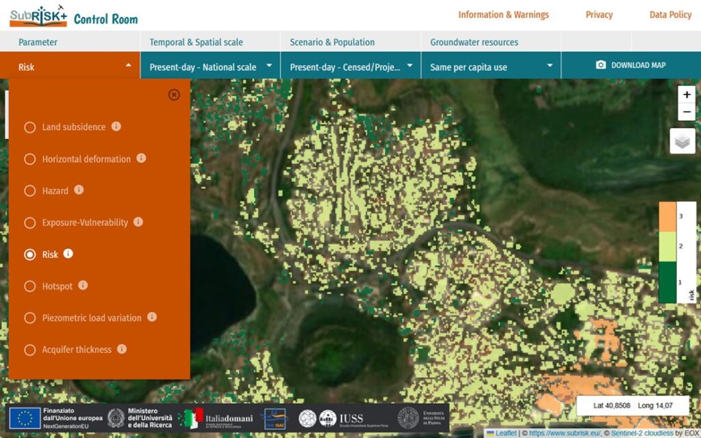
This collection of digital maps aims to provide a baseline risk assessment overview for the 15 metropolitan cities of Italy, in relation to the process of differential displacement induced by land subsidence/uplift. The maps illustrate the spatial distribution of present-day hazard, exposure-vulnerability and risk levels within each city and, as such, could provide valuable inputs for land subsidence-related risk management and mitigation workflows for national land management and urban authorities. The detailed description of the methodology that was employed to generate the maps is available in DEL2.2.
–> Go to SubRISK+ ‘Control Room‘ to explore the maps
DEL2.2 – Present-day land subsidence risk in Italy
This report presents the newly-developed methodology to assess land subsidence risk at the national scale, using satellite-derived ground displacement observations and land cover data. The methodology exploits InSAR datasets from the European Ground Motion Service (EGMS) of the Copernicus Programme, along with urban settlement characteristics from the Global Human Settlement Layer (GHSL) and the World Settlement Footprint (WSF) datasets. These are used to estimate present-day distribution and levels of hazard and exposure-vulnerability across the 15 metropolitan cities of Italy and, in turn, classify and map risk levels.
–> Full report: CIGNA F., PARANUNZIO R., BONÌ R. & TEATINI P. (2024). PRIN 2022 PNRR SubRISK+ Deliverable DEL 2.2: Present-day land subsidence risk in Italy, Version 1.0, Issue date: 30/09/2024, pp. 67.
–> See also the journal papers: Cigna et al. 2025, Lenardón Sánchez et al. 2024
WP3: Regional scale land subsidence analysis
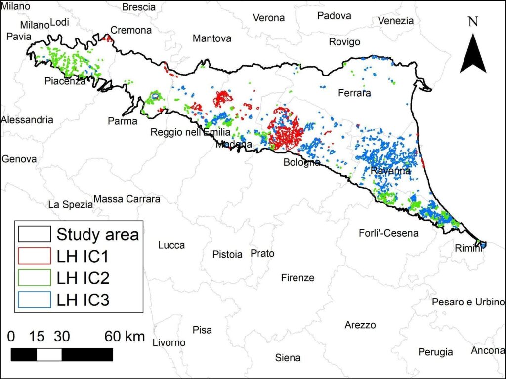
DEL3.1 – Land subsidence hotspots database for Emilia-Romagna region
This digital database provides a collection of land displacement hotspots identified within the plain of Emilia-Romagna region, based on advanced statistical analysis of InSAR displacement time series. Three main independent components (ICs) are identified within the time series (linear, non-linear, and seasonal trends), and homogeneous clusters with similar trends are delineated using an optimized hot spot analysis. Many land displacement drivers are investigated, including tectonics, soft soil compaction, groundwater withdrawal, infrastructural loading, hydrocarbon storage, and production. The detailed description of the methodology that was employed to generate the database is available in DEL3.3.
–> Go to SubRISK+ ‘Control Room‘ to access the database
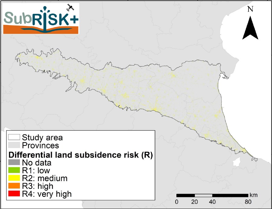
DEL3.2 – Land subsidence risk map for Emilia-Romagna region
This collection of digital maps aims to provide a differential displacement risk assessment overview for the plain of Emilia-Romagna region in northern Italy, over an investigated area of >10,000 km2. The exposure-vulnerability and risk maps are obtained by exploiting the building footprint database distributed by Emilia-Romagna Region, and thus provide an enhanced regional scale overview of the baseline risk scenario for this territory. Four risk levels, ranging from low to very high, are distinguished, thus offering relevant information to various stakeholders, such as regional land management and urban authorities. The detailed description of the methodology that was employed to generate the maps is available in DEL3.3.
–> Go to SubRISK+ ‘Control Room‘ to explore the maps
DEL3.3 – Driving and conditioning factors of the land subsidence in Emilia-Romagna region
This report presents the findings of the identification of land subsidence hotspots, the interpretation of the key drivers of the movement, and the assessment of risk for Emilia-Romagna, an Italian region where land subsidence has reached alarming levels, forcing regional and local authorities to take legislative measures aimed to control the process (Italian Law n.845, 10/12/1980). The analysis exploits InSAR datasets from Copernicus EGMS, geological and hydrogeological datasets available via the geoportal of the Emilia-Romagna region and ARPAE.
–> Full report: BONÌ R., GOLIRAEISI L., SAPIO S., TARAMELLI A., CIGNA F., PARANUNZIO R. & TEATINI P. (2025). PRIN 2022 PNRR SubRISK+ Deliverable DEL 3.3: Driving and condition factors of the land subsidence in Emilia-Romagna region, Version 1.0, Issue date: 31/01/2025, pp. 53.
–> See also the journal paper: Farías et al. 2024
WP4: Advanced local scale modeling
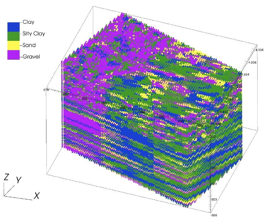
DEL4.1 – Static 3D model of a (multi)aquifer system underlying a metropolitan city in Italy
This is a city-scale 3D lithofacies (i.e. stochastic) model for a ~120 km2 area encompassing Bologna city centre and its suburban fringe, reflecting the high heterogeneity and uncertainty of its aquifer system. The geological and hydrogeological datasets that provide the conditional inputs for the lithofacies simulations are obtained from the Emilia-Romagna geoportal and ARPAE. The model is distributed in VTK (Visualisation ToolKit) format, along with supporting files generated using the GEN3D software and the GEOST tool. It can be readily imported into visualisation environments, e.g. VisIt and ParaView.
–> Compressed 3D facies model and supporting files (~450 MB uncompressed)
–> Accompanying report: TANG X., TEATINI P., ZOCCARATO C., BONÌ R., CIGNA F. & PARANUNZIO R. (2025). PRIN 2022 PNRR SubRISK+ Deliverable DEL 4.1: Static 3D model of a (multi)aquifer system underlying a metropolitan city in Italy. The Bologna case study, Version 1.0, Issue date: 31/07/2025, pp. 31.
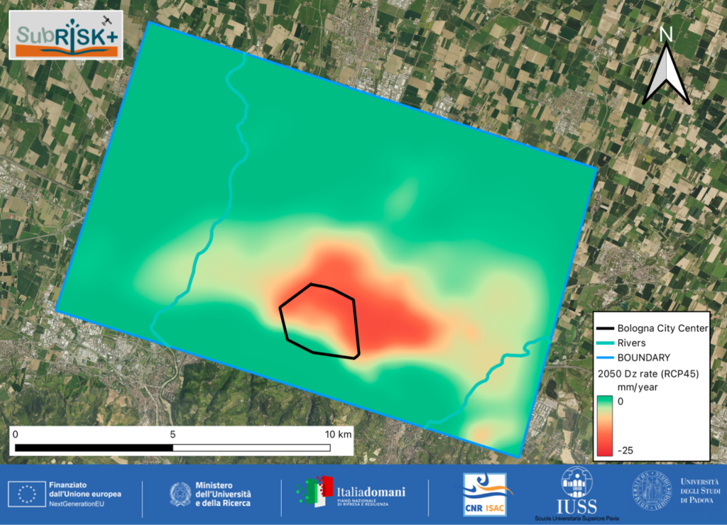
DEL4.2 – Vertical and horizontal displacement maps from the simulator outputs
These digital maps showcase the 3D ground displacement field of the ~120 km2 study area within the city of Bologna, resulting from fluid-dynamic and geomechanical modeling. The collection includes maps of vertical and horizontal displacements along the west-east and south-north directions, for the present-day scenario, 2050 and 2100, the latter accounting for the RCP4.5 and RCP8.5 emission scenarios. The detailed description of the methodology that was employed to generate the maps is available in DEL4.3.
–> Go to SubRISK+ ‘Control Room‘ to explore the maps
DEL4.3 – Modeling subsurface deformations and surface displacements at metropolitan-city scale
This report presents the development of an advanced modelling framework implemented in the heterogeneous aquifer system of Bologna, by coupling a 3D fluid-dynamic model with a 3D geomechanical model, to estimate the piezometric level evolution and the following 3D displacement field. The uncertainty of the hydro-geomechanical parameters (hydraulic conductivity and soil compressibility) was reduced by assimilating yearly piezometric measurements recorded in 1976-2021 and InSAR-derived land subsidence rates in 1992-2021. The model simulations were extended to 2050 and 2100, investigating the expected evolution in relation to the RCP 4.5 and RCP 8.5 emission scenarios.
–> Full report: TANG X., TEATINI P., ZOCCARATO C., BONÌ R., CIGNA F. & PARANUNZIO R. (2026). PRIN 2022 PNRR SubRISK+ Deliverable DEL 4.3: Numerical modelling on hydrodynamics and land subsidence coupling with Bayesian-based data assimilation, the Bologna case study, Version 1.0, Issue date: 28/02/2026, pp. 52.
WP5: Socio-economic impact analysis
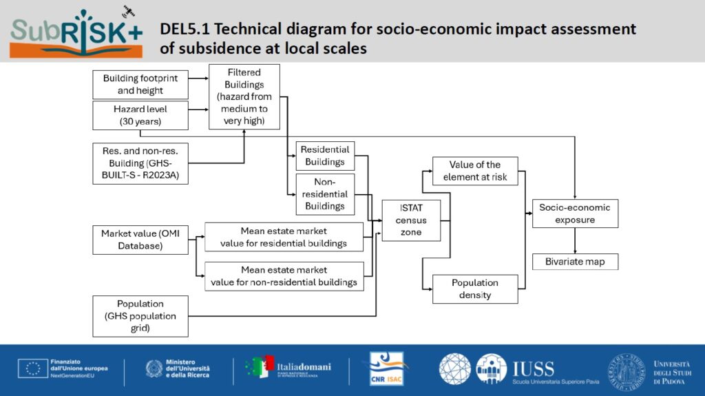
DEL5.1 – Technical diagrams for socio-economic impact assessment of subsidence at national, regional and local scales
These three diagrams depict the newly developed workflows enabling the assessment of direct and indirect economic exposure to differential land displacement at national, regional and local scales. The diagrams are incorporated within DEL5.2 technical report.
DEL5.2 – Current impacts at national, regional and local scales
This report provides a comprehensive assessment of the direct and indirect socio-economic exposure to land subsidence across the 15 metropolitan cities of Italy, the Emilia-Romagna region, and the city of Bologna. The analysis integrates differential displacement hazard maps produced at the national and regional scales in WP2-WP3, economic asset values from the real estate market observatory, population density data from GHSL, and EGMS vertical ground displacements. Three levels of socio-economic exposure from low to high are distinguished taking into account the population density and the amount in euro of residential and non-residential elements at risk. Through advanced integration of the input layers, the study provides a multi-scalar understanding of potential direct and indirect impacts of land subsidence.
–> Full report: BONÌ R., GOLIRAEISI L., SAPIO S., TARAMELLI A., CIGNA F., PARANUNZIO R. & TEATINI P. (2025). PRIN 2022 PNRR SubRISK+ Deliverable DEL 5.2: Report on the current impacts at national, regional and local scales, Version 1.0, Issue date: 31/05/2025, pp. 53.
WP6: Future scenarios analysis
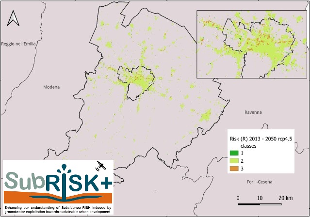
DEL6.1 – Land subsidence risk maps for the 15 metropolitan cities of Italy for 2050 and 2100
This collection of digital maps provides future risk assessment overviews for the 15 metropolitan cities of Italy in 2050 and 2100, in relation to the process of differential displacement induced by land subsidence/uplift. The maps illustrate the spatial distribution of future hazard, exposure-vulnerability and risk levels within each city, accounting for RCP 4.5 and RCP 8.5 emission scenarios. The detailed description of the methodology that was employed to generate the maps is available in DEL6.3.
–> Go to SubRISK+ ‘Control Room‘ to explore the maps
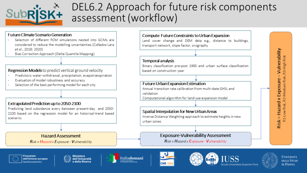
DEL6.2 – Approach for future risk components assessment
This workflows showcases the technical approach that was adopted to assess future risk scenarios related to differential ground displacement at the national scale , by accounting for satellite InSAR data, climate projections, and modeled urban expansion. The detailed description of the workflow is available in DEL6.3.
–> Workflow: PARANUNZIO R., CIGNA F., BONÌ R. & TEATINI P. (2026). PRIN 2022 PNRR SubRISK+ Deliverable DEL 6.2: Approach for future risk components assessment (workflow), Issue date: 28/02/2026.
DEL6.3 – Future land subsidence risk in the metropolitan cities of Italy
This report presents the novel methodology developed to assess future scenarios of land subsidence risk at the national scale, based on climate data in-situ observations and projections (E-OBS and CORDEX), satellite-derived ground displacement observations (Copernicus EGMS), urban settlements and land cover data (GHSL, WSF, CORINE Land Cover and OSL), and groundwater withdrawals from ISTAT. The future distribution and levels of hazard and exposure-vulnerability across the 15 metropolitan cities of Italy in 2050 and 2100 were assessed accounting for the RCP 4.5 and RCP 8.5 scenarios and, in turn, the resulting risk levels were mapped.
–> Full report: PARANUNZIO R., CIGNA F., BONÌ R. & TEATINI P. (2026). PRIN 2022 PNRR SubRISK+ Deliverable DEL 6.3: Future land subsidence risk in the metropolitan cities of Italy, Version 1.0, Issue date: 28/02/2026, pp. 36.