27th February 2026, h. 11:00-16:00 CET | online
Land subsidence-induced risk to urban environments: present-day baseline and future scenarios
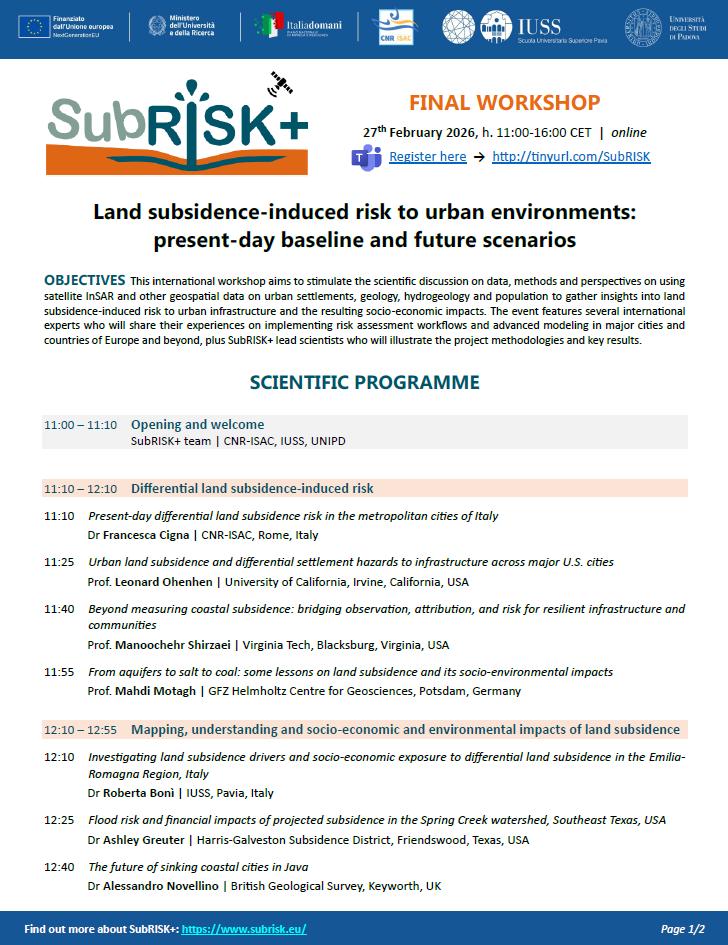
SubRISK+ approached its final stage, and the project team organised an international workshop aimed to stimulate the scientific discussion on methods and perspectives on using satellite InSAR and other geospatial data on urban settlements, geology, hydrogeology and population to gather insights into land subsidence-induced risk to urban infrastructure and the resulting socio-economic impacts.
See the scientific programme here:
Full Programme (updated on 23/02/2026)
The event featured several international experts who shared their experiences on implementing risk assessment workflows and advanced modeling in major cities and countries of Europe and beyond, plus SubRISK+ lead scientists who illustrated the project methodologies and key results.
The workshop was held online using Microsoft Teams, and participation was free and open to the scientific community, remote sensing and geohazard specialists, stakeholders and the public.
Workshop materials and links to key articles and other resources shared by the speakers are available here (uploading in progress):
| Schedule | Title & Speaker | Materials & Links |
|---|---|---|
| 11:00 | Opening and welcome SubRISK+ team | CNR-ISAC, IUSS, UNIPD | Presentation: PPT |
| 11:10 | Present-day differential land subsidence risk in the metropolitan cities of Italy Dr Francesca Cigna | CNR-ISAC, Rome, Italy | Presentation: PPT Papers: Cigna et al. 2025, Lenardón Sánchez et al. 2024 Deliverables: SubRISK+ DEL2.2 |
| 11:25 | Urban land subsidence and differential settlement hazards to infrastructure across major U.S. cities Prof Leonard Ohenhen | University of California, Irvine, California, USA | Presentation: PPT Papers: Ohenhen et al. 2024, Ohenhen et al. 2025 |
| 11:40 | Beyond measuring coastal subsidence: bridging observation, attribution, and risk for resilient infrastructure and communities Prof Manoochehr Shirzaei | Virginia Tech, Blacksburg, Virginia, USA | Presentation: PPT Papers: Shirzaei et al. 2026 |
| 11:55 | From aquifers to salt to coal: some lessons on land subsidence and its socio-environmental impacts Prof Mahdi Motagh | GFZ Helmholtz Centre for Geosciences, Potsdam, Germany | Presentation: PPT Papers: Haghshenas Haghighi & Motagh 2024, Vassileva et al. 2021 |
| 12:10 | Investigating land subsidence drivers and socio-economic exposure to differential land subsidence in the Emilia-Romagna Region, Italy Dr Roberta Bonì | IUSS, Pavia, Italy | Presentation: PPT Papers: Bonì et al. 2024, Farías et al. 2024 Deliverables: SubRISK+ DEL3.3, SubRISK+ DEL5.2 |
| 12:25 | Flood risk and financial impacts of projected subsidence in the Spring Creek watershed, Southeast Texas, USA Dr Ashley Greuter | Harris-Galveston Subsidence District, Friendswood, Texas, USA | Presentation: PPT Papers: Harris-Galveston research studies |
| 12:40 | The future of sinking coastal cities in Java Dr Alessandro Novellino | British Geological Survey, Keyworth, UK | Presentation: PPT Papers: Hourston et al. 2026 |
| 14:00 | Assimilation of piezometric records and InSAR data to model land subsidence in Bologna, Italy Prof Pietro Teatini | UNIPD, Padua, Italy | Deliverables: SubRISK+ DEL4.1, SubRISK+ DEL4.3 |
| 14:15 | The importance of hydrogeological models in land subsidence simulations Prof Shih-Jung Wang | National Central University, Taoyuan City, Taiwan | Presentation: PPT Papers: Tran et al. 2022, Wang et al. 2022, Truong et al. 2025, Tranet al. 2025 |
| 14:30 | Integrating neural network, InSAR and field measurements to model land subsidence evolution in the Beijing plain Prof Lin Zhu | Capital Normal University, Beijing, China | Presentation: PPT Papers: Li et al. 2021, Li et al. 2025 |
| 14:45 | Subsidence and building damage: a model chain Dr Thibault Candela | TNO, Utrecht, The Netherlands | |
| 15:00 | Projected land subsidence risk under climate change and groundwater withdrawal scenarios in the metropolitan cities of Italy Dr Roberta Paranunzio | CNR-ISAC, Rome, Italy | Presentation: PPT Deliverables: SubRISK+ DEL6.3 |
| 15:15 | Land subsidence drivers, interactions, and cascading impacts: Opportunities and insights Prof Laurie S. Huning | California State University, Long Beach, California, USA | Presentation: PPT Papers: Huning et al. 2024 |
| 15:30 | Subsidence & sinkholes: Perspectives and current research at Uni Leipzig Dr Djamil Al-Halbouni | University of Leipzig, Leipzig, Germany | Presentation: PPT Papers: Al-Halbouni et al. 2017, Alrabayah et al. 2024, Al-Halbouni et al. 2022a & 2022b |